|
>>
|
No. 31302
[Edit]
File
151555053234.png
- (1.42MB
, 2292x2012
, Transit question.png
)

>>31294
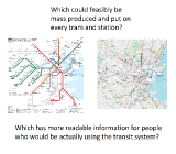
The purpose of a transit map is to convey basic information on an easily replicatable, easily read format, not to give an accurate geographical representation of the area served. It holds all the pertinent information a person would need to use a transit system. It has a simple and easily read format for someone attempting to find their way around a subway system, going by their closest station and finding the closest station to their destination.
By default all maps serve a specific purpose, and every map can, does, and will omit information to that end. Imagine a history textbook about the Vietnam War that went into detail about the botanical information of the jungle, each species of plant by their genus and species name and their reproductive methods.
Any transit system worth their salt will put a detailed map of the street layout of the area within 100-500 meters of the station, but it's useless to put a station map with every street corner and building on it, as the pertinent information is lost to begin with in the rest of the noise. Someone on public transit won't need to know where Interstate 93 is, but they all will need to know the order of stops on a train.
Part of infrastructure is cost, another part is implementation. So imagine the process of production to make geographically correct maps of a transit system to be published in all sorts of forms (pamphlet, website, posters, cards, wall maps, etc). Now imagine the vast amount of wasted space that would be taken up by a map where a line has several stops per mile in high density areas but miles between spots in low density areas (as is the case with my map between two cities with two lower density towns between them). You need to print such a map large enough to not crowd the high density areas, so in short, you would have a map that only works as a large poster of abnormal proportions, or is completely unreadable in any way if you try to print it in a portable format, completely destroying the point of a transit map.
|